Adelaide & Adelaide Hills | Barossa | Clare Valley | Flinders Ranges & Outback
Cycling | Walking
Cycling | Walking
| Start Point | Gorge Road, SA |
| End Point | Blinman, Flinders Ranges, SA |
| Distance | 900km |
| Time | 2.32 Weeks – Cycling |
| Time | 3.62 Weeks – Walking |
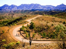
Starting just north of Adelaide and travelling to the Outback town of Blinman in the Flinders Ranges, the Mawson Trail is the ideal option for mountain bikers wanting to travel through the picturesque scenery of South Australia’s remote rural areas.
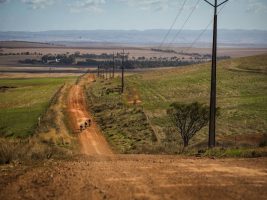
Close to nine hundred kilometres long, the trail includes little-used country roads, State forest and national park fire trails, farm access tracks and unmade or unused road reserves. It avoids traffic and bitumen roads and leads cyclists into the remote areas of the Ranges.
The trail takes riders through the Adelaide Hills, traversing forests, farmland and historic towns such as Lobethal and Birdwood. It passes the world-famous Barossa wine region to the mid-north towns of Kapunda and Burra and, from here, winds pass the towns of Hallett and Spalding through the Bundaleer Forest and into the Flinders Ranges.
The Mawson Trail is designed for mountain bike or sturdy touring bike use – it is not suitable for road bikes. There are several steep uphill sections and heavy rain on unmade tracks can make cycling very slow or impossible. However, spectacular views, abundant wildlife, unique flora and extensive vistas always reward the hard physical work.
For the official, essential, Mawson Trail maps at 1:750,000 scale contact:
Bicycle SA, 53 Carrington Street, Adelaide SA 5000.
Ph 8168 9999.
Email: office@bikesa.asn.au
The 9 individual Mawson Trail maps in 3 separate map packs are well annotated with history and sights along the way and each covering 100km of the track. They show how to get into and out of the towns and that’s surprisingly useful. Also shows the typography for each day.
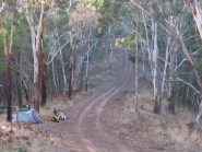
The trail is open all year round, however the months of January to March can be fiercely hot and are best avoided.
Download the Mawson Transport Guide here.
The trail is marked with a distinctive logo attached to a square one-metre high, permapine post. These trail
markers are placed at intersections, turn-offs and at one-kilometre intervals along the length of the trail.
The Mawson Trail is designed for mountain bike or sturdy touring bike use – it is not suitable for road bikes. Steep sections and areas of rough terrain mean that there will be a lot of walking unless you have very low gears.
Cyclists must have adequate spare tyres and provisions, and be prepared to ride off the bitumen and over rough and difficult terrain. It is highly recommended that you travel in a group of three or more, in case of accident or mechanical breakdown.
Correct and thorough bicycle preparation cannot be overemphasised, especially for those carrying panniers. Cyclists unfamiliar with any aspect of their bicycle’s mechanical function should seek expert advice prior to departure.
All cyclists should have provision for at enough water for the trip on their bicycles for use while riding, with more inside panniers for camping. All biddon cages should be checked for cracks and distortions, and mountings should be tight. Water requirements will vary according to the
season but should never be underestimated. Water in creeks, waterholes and on the ground should never be drunk. Excessive heat will cause riders to consume a lot of water. In these conditions, a support vehicle should be considered.